Lifestyle
Severe Flood in Pakistan: Causes, Impact & Future Risks
Flood in Pakistan: A Growing National Crisis
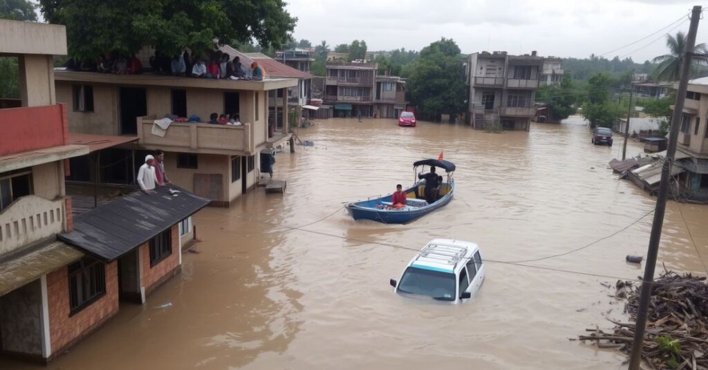
Flood in Pakistan is no longer a rare event. It has become a yearly challenge, with massive rains and swollen rivers sweeping across the country. From northern valleys to southern plains, floods leave behind damage that takes months, even years, to recover from.
Pakistan experiences two main types of floods: river floods and urban floods. River floods mostly come from the Indus River system, especially when there is heavy rainfall or glacier melt in the north. Urban floods, on the other hand, are caused by blocked drainage systems and unplanned cities, especially in major areas like Karachi, Lahore, and Islamabad.
In recent years, climate change has made the flood in Pakistan worse. Rain patterns have become more intense and unpredictable. Deforestation, poor planning, and weak infrastructure make the problem even harder to manage. Millions of people lose their homes, crops, and access to clean water every time it rains too much.
Understanding the reasons behind these floods is key to solving the problem. Let’s explore the causes, impacts, and solutions that can help reduce future risks.
Causes of Flood in Pakistan
The flood in Pakistan has many causes, both natural and man-made. The biggest reason is monsoon rainfall. Between July and September, Pakistan receives most of its yearly rain. When the rain is heavier than expected, rivers overflow and cause floods.
Another major cause is glacier melting. Pakistan is home to many glaciers in the northern areas. When temperatures rise, the glaciers melt faster. This increases the water level in rivers, especially during summer. This extra water can trigger sudden floods in the lowland areas.
Deforestation is also a major problem. Trees help absorb rainwater and slow down runoff. When forests are cut down for construction or farming, the land loses its natural protection. Water flows quickly and floods low-lying areas.
Poor drainage systems in cities also cause floods. Karachi, for example, suffers from severe urban flooding every year. Storm drains are blocked, and roads are not built to handle large amounts of water.
Lastly, climate change is increasing the risk. Pakistan has seen rising temperatures, changing rainfall patterns, and more extreme weather. All these changes increase the chances of frequent and powerful floods.
Recent Major Flood Events in Pakistan
Floods in Pakistan have become a yearly disaster. Some of the worst events in recent history include the 2010 floods, the 2022 super floods, and the 2025 monsoon floods.
The 2010 floods were among the worst in Pakistan’s history. Around one-fifth of the country was underwater. Over 20 million people were affected, and thousands lost their lives. Entire villages were swept away, and the economy suffered a major hit.
In 2022, Pakistan faced another deadly flood. Heavy monsoon rains and glacier melt caused rivers to overflow. Over 1,700 people died, and millions were displaced. Crops were destroyed, homes collapsed, and many roads and bridges were damaged.
More recently, in 2025, Pakistan again faced severe flooding during the monsoon season. Several provinces, including Sindh and Punjab, reported damage to crops, livestock, and infrastructure. The government declared a national emergency and called for international help.
Here’s a quick comparison of these flood disasters:
| Year | Affected People | Death Toll | Area Under Water | Main Causes |
| 2010 | 20+ million | ~2,000 | 1/5 of country | River overflow, heavy rain |
| 2022 | 33 million | ~1,700 | Large parts of Sindh, Balochistan | Monsoon rain, glacier melt |
| 2025 | 12 million (est.) | 800+ | Lower Punjab, Sindh, KP | Monsoon rain, poor drainage |
Impact of Flood in Pakistan on People and Economy
The flood in Pakistan has deep effects on people’s lives and the country’s economy. Each flood damages homes, schools, hospitals, and roads. Families lose everything overnight, from shelter to food and clean water.
For people living in rural areas, the flood destroys crops and livestock. Since agriculture is a major part of Pakistan’s economy, this causes food shortages and price increases. Farmers often need years to recover from these losses.
The damage also affects children and education. Schools get flooded or used as shelters, and children stop attending for weeks or even months. Health risks increase too. Stagnant water becomes a breeding ground for diseases like cholera, malaria, and dengue.
Economically, Pakistan loses billions of rupees every time there’s a major flood. The cost of rebuilding roads, restoring crops, and helping affected people takes away resources from other important areas.
Floods also reduce investor confidence and slow down development projects. In short, floods pull the country backward and increase poverty.
Government Response and Relief Efforts
Whenever there is a major flood in Pakistan, the government steps in with rescue and relief efforts. These include evacuating people, setting up camps, and providing food and medical help.
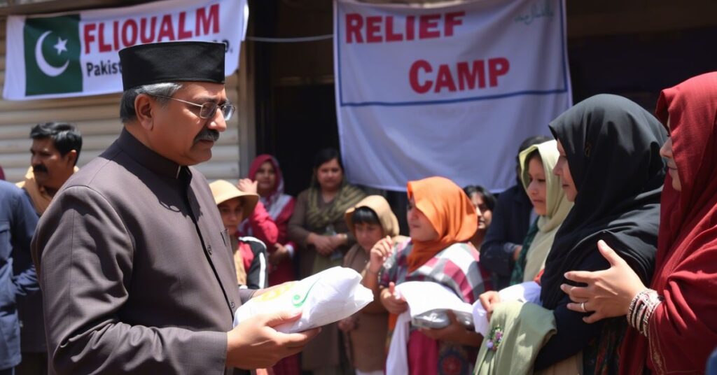
The National Disaster Management Authority (NDMA) is the main agency handling flood emergencies. They work with local governments, the army, and international aid groups to deliver help.
Helicopters are often used to reach remote areas. Tents, medicines, and food packs are sent to affected regions. Volunteers and NGOs also play a huge role in helping people on the ground.
However, many people feel that the response is too slow or not enough. In some cases, areas remain underwater for weeks, and victims wait long for help.
To improve future response, experts suggest better early warning systems, strong flood barriers, and improved city planning. The government has started projects like flood forecasting centers and river embankments, but much more is needed to stop the cycle of loss.
How Climate Change is Making Flood in Pakistan Worse
The link between climate change and flood in Pakistan is becoming clearer every year. Pakistan contributes very little to global carbon emissions, but it faces serious climate effects.
One of the biggest impacts is irregular and intense rainfall. Climate change has changed monsoon patterns. Some years bring little rain, while others bring too much at once, leading to flash floods.
Glaciers in the north are melting faster than before. Rising global temperatures mean more ice melts during summer, filling rivers beyond capacity. This leads to glacial lake outburst floods (GLOFs), which are sudden and deadly.
Changing weather also increases the risk of urban flooding. Cities are not built to handle such large amounts of water. Climate models suggest that heavy rains will become more common in Pakistan in the coming decades.
To face this crisis, Pakistan needs long-term plans. These include building stronger infrastructure, protecting forests, and switching to climate-friendly practices in farming and energy.
Solutions to Reduce Future Flood Risks in Pakistan
There is no single solution to stop the flood in Pakistan, but many steps can help reduce the damage. The first is better planning and early warnings. When people get alerts ahead of time, they can move to safer places.
Building stronger drainage systems in cities can prevent urban flooding. Roads and stormwater pipes need upgrades to carry water away quickly. In rural areas, better river embankments can protect villages from overflow.
Tree plantation is another key step. Forests help reduce runoff and hold the soil in place. The more trees there are, the less chance of flooding.
Education and awareness also matter. People should know how to react during floods, where to go, and how to protect their families.
International support and climate funds can help Pakistan build a flood-resilient future. But local actions like responsible construction, waste management, and smart agriculture are just as important.
FAQs About Flood in Pakistan
Q1: Why does flood in Pakistan happen every year?
Floods happen mostly due to heavy monsoon rains, glacier melt, poor drainage, and deforestation.
Q2: What are the worst flood years in Pakistan’s history?
The worst floods were in 2010, 2022, and 2025. Each caused massive damage to people, homes, and the economy.
Q3: How does climate change affect floods in Pakistan?
It causes irregular rainfall and faster glacier melting, which leads to more intense and frequent floods.
Q4: What can the government do to reduce flood damage?
They can improve early warning systems, build flood defenses, fix drainage, and educate the public.
Q5: How can citizens help during a flood crisis?
People can volunteer, donate, spread awareness, and follow safety guidelines during emergencies.
Introduction
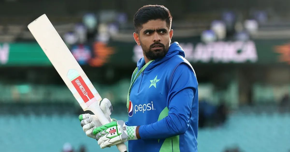
In modern cricket, few players combine elegance, consistency, and leadership as effectively as Babar Azam which is Pakistan’s stylish Run Machine. Widely regarded as one of the finest batsmen of his generation, Babar has become the backbone of Pakistan’s batting lineup. His stylish stroke play, calm temperament, and ability to score runs across all formats have earned him the nickname “Pakistan’s Stylish Run Machine.” Through dedication and remarkable skill, Babar has established himself as a global cricket star and an inspiration for young cricketers.
Early Life and Background
Babar Azam was born on October 15, 1994, in Lahore. Coming from a cricket-loving family, he developed an interest in the sport at a very young age. He is also related to famous Pakistani cricketers Kamran Akmal and Umar Akmal, who helped guide him during his early career.
Babar trained in Lahore’s cricket academies where coaches quickly noticed his natural batting talent and discipline. His strong performances in youth cricket soon earned him a place in Pakistan’s Under-19 team.
Rise Through Youth Cricket
Babar represented Pakistan in the ICC Under‑19 Cricket World Cup in both 2010 and 2012. During these tournaments, he showcased his impressive batting technique and consistency.
His performances at the youth level attracted national selectors and paved the way for his entry into professional cricket.
International Debut and Early Career
Babar made his One Day International (ODI) debut for Pakistan in 2015 against Zimbabwe national cricket team. Soon after his debut, he started scoring runs consistently and proved himself as a reliable top-order batsman.
In 2016, Babar gained global attention when he scored three consecutive ODI centuries against West Indies cricket team. This remarkable achievement placed him among the elite young batsmen in world cricket.
Batting Style and Strengths
Babar Azam is admired for his classic batting technique and elegant stroke play. His cover drive is often compared with the best shots played by legendary cricketers. Key strengths of his batting include:
- Excellent timing and balance
- Strong shot selection
- Ability to anchor the innings
- Consistency in all formats of the game
- Calmness under pressure
Because of these qualities, Babar is often compared with modern greats like Virat Kohli, Joe Root, and Kane Williamson.
Captaincy and Leadership
Babar Azam also served as the captain of the Pakistan national cricket team in different formats. Under his leadership, Pakistan achieved several notable victories and improved its ranking in international cricket.
His calm personality and professional attitude helped build a strong team environment and inspired young players to perform better.
Records and Achievements
Throughout his career, Babar Azam has achieved numerous milestones, including:
- Becoming one of the fastest players to reach 5000 ODI runs
- Scoring centuries in all three formats of international cricket
- Ranking among the top batsmen in ICC rankings
- Leading Pakistan to several important series victories
His consistency and performance have made him one of Pakistan’s most dependable cricketers.
Impact on Pakistan Cricket
Babar Azam’s success has had a huge impact on cricket in Pakistan. Young players admire his dedication, discipline, and professional approach to the game. He has become a role model for aspiring cricketers who dream of representing their country at the highest level.
Conclusion
Babar Azam truly deserves the title “Pakistan’s Stylish Run Machine.” His elegant batting, impressive records, and leadership qualities have made him one of the most important figures in modern cricket. As his career continues to grow, cricket fans around the world eagerly watch his performances, expecting many more memorable innings in the years to come.
With talent, determination, and passion for the game, Babar Azam remains a shining star in the history of Pakistan cricket.
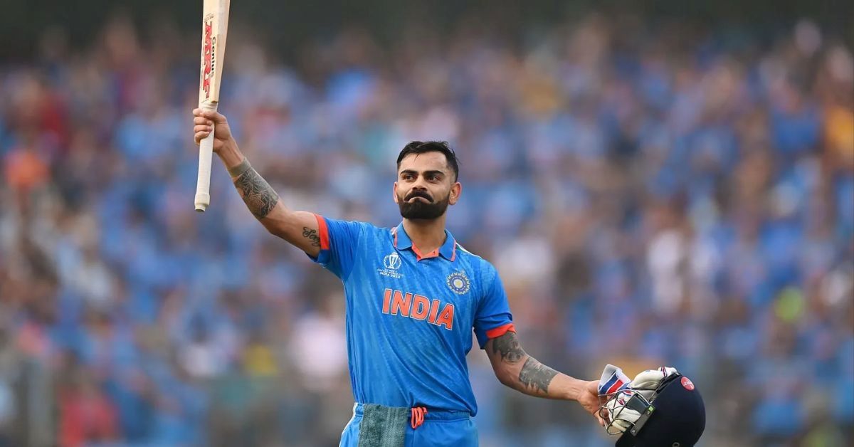
Virat Kohli is widely regarded as one of the greatest cricketers of the modern era. Known for his aggressive playing style, remarkable consistency, and strong leadership, Kohli has become a global icon in the world of cricket. His journey from a young cricket enthusiast in India to one of the most successful players in international cricket is a story of determination, talent, and hard work.
Early Life and Passion for Cricket
Virat Kohli was born on November 5, 1988, in Delhi. From a very young age, he showed an immense passion for cricket. Recognizing his talent, his father enrolled him in the West Delhi Cricket Academy where Kohli began professional training.
Kohli quickly developed a reputation as a talented batsman with a strong competitive spirit. His dedication and hard work helped him progress rapidly through the ranks of youth cricket in India.
Breakthrough in International Cricket
Virat Kohli gained international recognition when he captained the India Under-19 cricket team to victory in the ICC Under-19 Cricket World Cup 2008.
Later that same year, he made his debut for the India national cricket team in One Day Internationals. Over time, Kohli established himself as one of the most reliable batsmen in the team with his ability to chase targets and perform under pressure.
Dominance in International Cricket
Virat Kohli soon became one of the most consistent run scorers in international cricket. His batting style combines technical excellence with aggressive intent.
Some of his major achievements include:
- Scoring thousands of runs across all formats of international cricket
- Being among the fastest players to reach multiple batting milestones
- Winning several Player of the Series awards
- Ranking among the top batsmen in ICC rankings for many years
Kohli is especially known for his outstanding performances in ICC Cricket World Cup and other major tournaments.
Leadership as Captain
Virat Kohli also served as captain of the India national cricket team across multiple formats. As captain, he focused on building a strong and competitive team.
Under his leadership:
- India achieved historic test series victories overseas
- The team maintained the number one ranking in Test cricket for several years
- Fitness and discipline became a major focus for the squad
Kohli’s aggressive leadership style helped transform the team into one of the strongest sides in international cricket.
Success in the Indian Premier League
Apart from international cricket, Kohli has also been a major star in the Indian Premier League.

He has played for Royal Challengers Bangalore since the beginning of his IPL career. Kohli holds several IPL records, including one of the highest run totals in a single season.
His performances in the league have made him one of the most popular players in T20 cricket.
Also in the presence of kohli Royal Challengers Bangalore Win IPL 2025 season.
Fitness, Discipline, and Work Ethic
One of the defining characteristics of Virat Kohli’s success is his extraordinary fitness and discipline. He is known for maintaining strict training routines, a balanced diet, and intense workout sessions.
His commitment to fitness has inspired many young cricketers to focus on physical conditioning as an essential part of the sport.
Influence Beyond Cricket
Beyond the cricket field, Kohli is also a global celebrity and entrepreneur. He has collaborated with several major brands and launched his own ventures.
He is married to Anushka Sharma, one of India’s leading film actresses. Together, they are considered one of the most influential celebrity couples in India.
Kohli is also actively involved in charity work through the Virat Kohli Foundation, which supports underprivileged children and promotes sports development.
Legacy and Impact
Virat Kohli’s influence on modern cricket is undeniable. His aggressive batting style, leadership qualities, and unmatched consistency have set new standards for future generations of cricketers.
Young players around the world admire him for his passion, determination, and relentless pursuit of excellence.
Conclusion
The rise of Virat Kohli from a young cricket lover in Delhi to one of the greatest modern cricketers is truly inspiring. His journey reflects the importance of talent, hard work, discipline, and self-belief.
As he continues to perform at the highest level, Kohli’s legacy as a modern cricket legend will remain a source of inspiration for cricket fans and aspiring athletes around the world.

Cristiano Ronaldo is widely regarded as one of the greatest football players in history. Known for his incredible athleticism, goal-scoring ability, and unmatched dedication, Ronaldo has inspired millions of fans across the world. His journey from a young boy in Portugal to a global football icon is a story of talent, hard work, and perseverance.
Early Life and Childhood
Cristiano Ronaldo dos Santos Aveiro was born on February 5, 1985, in Funchal. He grew up in a modest family where financial struggles were common. Despite these challenges, Ronaldo showed an early passion for football.
As a child, he played for a local club called Andorinha, where his father worked as a kit manager. His talent quickly became noticeable, and he later joined the youth academy of Sporting CP.
At the age of 12, Ronaldo moved to Lisbon to train at Sporting’s academy. This was a difficult step because he had to leave his family behind, but it marked the beginning of his professional football journey.
Breakthrough at Manchester United
Ronaldo’s big break came in 2003 when he signed for Manchester United, one of the biggest clubs in England. The legendary manager Sir Alex Ferguson recognized Ronaldo’s potential and helped him develop into a world-class player.

During his time at Manchester United, Ronaldo achieved remarkable success:
- Won multiple Premier League titles
- Won the UEFA Champions League in 2008
- Won his first Ballon d’Or in 2008
His speed, dribbling skills, and goal-scoring ability made him one of the most exciting players in the world.
Legendary Era at Real Madrid
In 2009, Ronaldo transferred to Real Madrid for a then-record transfer fee. This move marked the most successful period of his career.
At Real Madrid, Ronaldo:
- Scored 450 goals in 438 appearances
- Won four Champions League titles
- Won four Ballon d’Or awards
His rivalry with Lionel Messi during this era created one of the most exciting periods in football history.
Ronaldo became Real Madrid’s all-time top scorer, solidifying his legacy as a football legend.
Success with the Portugal National Team
Ronaldo has also achieved great success with the Portugal national football team.
One of his greatest achievements came in UEFA Euro 2016, when Portugal won its first major international trophy.
He later helped Portugal win the UEFA Nations League Finals 2019.
Ronaldo is the top goal scorer in international men’s football, showing his consistency at the highest level.
Later Career and Global Influence
After leaving Real Madrid, Ronaldo played for Juventus, where he continued scoring goals and winning titles. He later returned to Manchester United before moving to Al Nassr in Saudi Arabia.
Beyond football, Ronaldo is a global brand. His influence extends to business, fashion, and fitness. His brand CR7 includes clothing, fragrances, and hotels.
He is also one of the most followed athletes on social media, inspiring millions with his work ethic and lifestyle.
Work Ethic and Training
One of the key reasons behind Ronaldo’s success is his extraordinary discipline and dedication.
His routine includes:
- Intense daily training
- Strict diet and nutrition
- Focus on physical fitness
- Mental determination
This commitment has allowed him to perform at an elite level for more than two decades.
Legacy and Impact on Football
Cristiano Ronaldo’s legacy goes far beyond statistics and trophies. He has changed modern football with his professionalism, athletic ability, and competitive spirit.
Young players around the world look up to him as a role model. His journey proves that talent combined with hard work can lead to greatness.
Conclusion
The rise of Cristiano Ronaldo from a small island in Portugal to one of the greatest footballers in history is truly remarkable. His dedication, determination, and passion for the game have made him a global icon.
Even after achieving countless records and trophies, Ronaldo continues to inspire fans and athletes worldwide. His story reminds us that dreams can become reality with discipline, perseverance, and belief in oneself.

Babar Azam: Pakistan’s Stylish Run Machine!!!

Virat Kohli: Rise of a Modern Cricket Legend!

Cristiano Ronaldo: Rise of a Football Legend!

Cristiano Ronaldo: Life, Career, and Legacy of a Football Star

Saiyaara Movie Overview: A Soulful Romantic Journey

What is Chainlink? Complete Guide to How It Works
-
 Lifestyle8 months ago
Cristiano Ronaldo: Life, Career, and Legacy of a Football Star
-
 Lifestyle8 months ago
Saiyaara Movie Overview: A Soulful Romantic Journey
-
 Lifestyle8 months ago
What is Chainlink? Complete Guide to How It Works
-
Lifestyle8 months ago
Understanding Crypto Market Volatility: Tips for Investors
-

 Lifestyle8 months ago
Yellowstone National Park: Travel, Nature & Wildlife Guide
-

 Lifestyle8 months ago
Trump Claims Musk ‘Off The Rails’ For Making Political Party
-

 Lifestyle8 months ago
Kawasaki Z650: Power, Performance, and Style Combined
-

 Lifestyle8 months ago
Cate Blanchett: Life, Career, Awards & Legacy Explored